


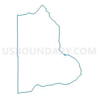
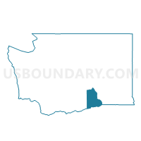
Hawthorne Voting District, Benton County, Washington
About
Outline

Summary
| Unique Area Identifier | 683433 |
| Name | Hawthorne Voting District |
| County | Benton County |
| State | Washington |
| Area (square miles) | 0.16 |
| Land Area (square miles) | 0.16 |
| Water Area (square miles) | 0.00 |
| % of Land Area | 100.00 |
| % of Water Area | 0.00 |
| Latitude of the Internal Point | 46.22431490 |
| Longtitude of the Internal Point | -119.18019650 |
Maps

Graphs
Select a template below for downloading or customizing gragh for Hawthorne Voting District, Benton County, Washington


Neighbors
Neighoring Voting District (by Name) Neighboring Voting District on the Map
- Kennewick 605 Voting District, Benton County, WA
- Kennewick 660 Voting District, Benton County, WA
- Kennewick 661 Voting District, Benton County, WA
- Umatilla Voting District, Benton County, WA
- Yellowstone Voting District, Benton County, WA